Pits Atlas: King 36
| Impact Melt pit: King | |
|---|---|
| Name | King 36 |
| Lat. | 6.214 |
| Long. | 119.7664 |
| Desc. | Elliptical pit with a rounded or conical floor, in a very subtle (~2-3m high?) rise. Most of the floor is covered in boulders, and the W half appears to slope towards the center at a ~30 degree angle. Wall height is up to ~10m (based on very high-Sun images), although there is a (very steep?) ramp from a point on the SW rim. No other collapse features in the area. |
| Types | |
| Terrain | Impact Melt |
| Host Feature | King |
| Funnel Min. Diam. | 45 |
| Funnel Max. Diam. | 51 |
| Inner Min. Diam. | 40 |
| Inner Max. Diam. | 46 |
| Azimuth | 180 |
| Depth | 11.0 |
| Depth 1 | 12.9 |
| Depth 2 | 11.6 |
| Depth 3 | 9.0 |
| Best Stereo Left | M143839277L |
| Best Stereo Right | M143839277L |
| DTMs | NAC_DTM_KINGCRATER3 |
| Clipping Width | 200 |
| Other IMGs | |
| Data Warning | Depth 1 is to lowest point, other measurements are to higher parts of the floor. |
| Entrance Ramp | Y? |
| Overhang | ? |
| Nearby Pits? | N |
| Nearby Fractures? | N |
| Nearby Depressions? | N |
| In Dome | Y |
| Beside Dome | N |
| In Depression | N |
| Colinear Pits | N |
| Colinear Depressions | N |
| Colinear Fractures | N |
| King 36 Shaded Relief | |
|---|---|
 |
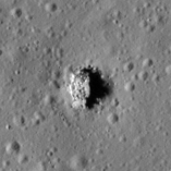
| M1153439131L | |
|---|---|
 |
|
| Line | 29528 |
| Sample | 2481 |
| Inc. Angle | 58.48 |
| Emission Angle | -1.81 |
| Time | 8.12 |
| Resolution | 1.28 |
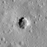
| M182745931L | |
|---|---|
 |
|
| Inc. Angle | -48.26 |
| Emission Angle | 2.04 |
| Time | 15.21 |
| Resolution | 1.27 |
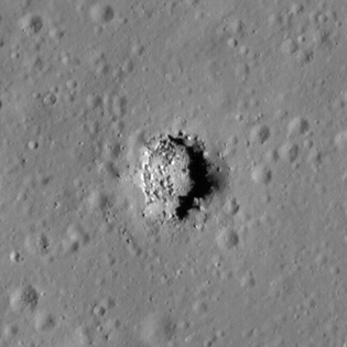
| M113168034R | |
|---|---|
 |
|
| Inc. Angle | 47.44 |
| Emission Angle | 0.25 |
| Time | 8.87 |
| Resolution | 0.62 |
| King 36 Stereo |
|---|
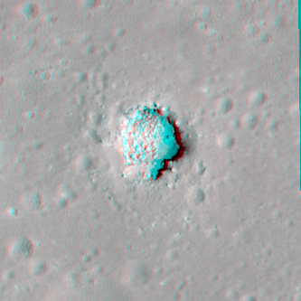 |